Merve CURA - 6
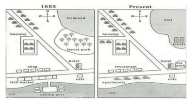
The map below shows the development of the village of Ryemouth between 1995 and present.
Summarize the information by selecting and reporting the main features and make comparisons where relevant.
The changes of a village named Ryemoth, from 1985 until today, are demonstrated by two maps. It can be seen that farmland and forest park were removed, and were replaced by some sports facilities. The fishing industry of the village demised, while the residential areas increased.
A careful look to the north of the maps reveals that in 1995 Raymoth had a forest park and farmland to the north-east of the village. Forrest park was cut down and merged together with the tract of former farmland. This area was converted into sports facilities, such as golf and tennis fields. It can also be seen that residential area in the north-west of the village did not show any dramatical changes, except the newly constructed buildings and the extension of the road leading to the west of the maps.
During the years, the south of the village witnessed spectacular changes, especially on the coast used by the fishing industry. In 1995, there was a fishing port and fishing market. From then to now, the fishing port and the markets demolished and were replaced by some apartments. The shops opposite the fish market were transformed into some restaurants. The hotel which was located to the south-east, despite to all changes, preserved its place and a car park was constructed next to the hotel.


Comments
Post a Comment